
Farallon Institute Newsletter - Winter 2020

Dr. Chelle Gentemann

Dr. Daisy Shi
Around The Office
Farallon Institute is proud to announce the addition of two excellent scientists to the group. Dr. Chelle Gentemann (above left) has been a long-time collaborator with FI and we are excited to have her join our team as a Senior Scientist. Chelle works on using satellites to measure sea surface temperature, salinity, and the exchange of heat between ocean and atmosphere...all important factors in weather prediction and accurate climate modeling. Her recent research focuses on interdisciplinary science using cloud computing, open source software development, and machine learning for applications. She has chaired numerous international science teams, working groups, and committees including serving as the current chair of the NOAA Science Advisory Board: Data Access and Archiving Requirements Working Group. At Farallon Institute, Chelle will work closely with biologists to integrate her knowledge of ocean conditions and explore how they influence marine ecosystems.
Dr. Daisy Hui Shi (above right) comes to FI after her Ph.D. study and postdoc research at University of Hawaii, Manoa. Daisy’s background includes atmospheric sciences, climate change and adaptation, and environmental engineering. Daisy has joined FI’s West Coast Climate Extreme project in a post-doctoral research position, bringing her experiences in general circulation models, statistical analysis and climate variability. She will focus on analyzing climate model simulations, and together with the team will develop proxies for extreme events like droughts, marine heat waves, hypoxia and harmful algal blooms along the California coast. The goal is to explore if these marine and terrestrial climate extremes would occur more frequently under future climate change.
We extend a warm welcome to both Daisy and Chelle. Read more about them here.
State of the Ocean
As ocean scientists, we all keep a close eye on what is happening in the ocean by checking a variety of sensors that automatically collect data on temperature, currents, waves, and even phytoplankton (small plants). We do this for an understanding of the ocean conditions and how they might impact food webs and fisheries, similar to the way people go to weather.com to check for rain in the forecast.
If you are interested in checking ocean conditions out for yourself, a great place to start is your regional ocean observing network. For central and northern Californians that would be CeNCOOS -- Central & Northern California Ocean Observing System -- where there is a treasure trove of data available. You can see data from buoys moored to the ocean floor (see below), from underwater gliders that patrol the depths, or ocean models that are similar to weather prediction models. Want ocean information in San Diego or Los Angeles? Check SCCOOS (Southern California Coastal OOS). Hawaii? PacIOOS -- Pacific Island OOS. There are OOS-es all over the United States and the world that help us see the ocean in a whole new way.

Screen capture from www.cencoos.org showing water temperature data available from buoys in San Francisco Bay and the Gulf of the Farallones.

GPS tracks of albatrosses in the Indian Ocean. Yellow dots indicate vessel radar detections. Exclusive Economic Zones are indicated by the yellow line around islands and other land masses. Figure 3 from Weimerskirch et al. (2020).
Albatrosses patrol fishing activity on the high seas
Albatrosses are very large birds that glide and range extensively over open ocean. While at sea, they are attracted to fishing vessels and often spend time flying near those ships. Fishing activity can be very difficult for authorities to monitor and enforce in remote areas of the ocean though all boats at sea are equipped with radar as a navigation tool and use Automatic Identification Systems (AIS) that broadcast their identity information via satellite. AISs can be turned off, however, and this is suspected to occur when vessels are engaged in illegal fishing efforts of international waters.
Researchers fit 169 albatrosses with loggers on their backs that could detect radar signals, record GPS locations, and had antennas to transmit data in real time. While the albatrosses foraged at sea the loggers sensed the radar signals from ships and recorded the corresponding GPS information. This information was merged in the data analysis stage of the study with the AIS data, which provided an identification match for a ship detected by the albatross based on the time and position of the recording. In some instances, the birds with loggers recorded the presence and location of a ship, but no match was available in the AIS database, which indicated that the ship had disabled their AIS broadcast. In international waters, more than one-third of all of the vessels detected did not have a functioning AIS, and this value was slightly lower near islands that have a national Exclusive Economic Zone.
These results indicate first that long-ranging seabirds such as albatrosses can be used to augment monitoring of fishing activity in very remote areas of the open ocean. Second, this study gives an indication of the prevalence of illegal fishing activities that are occurring in those vast areas of the ocean, which can inform and improve fisheries management and conservation efforts.
This study was published by Weimerskirch et al. in the journal Proceedings of the National Academy of Sciences of the USA.
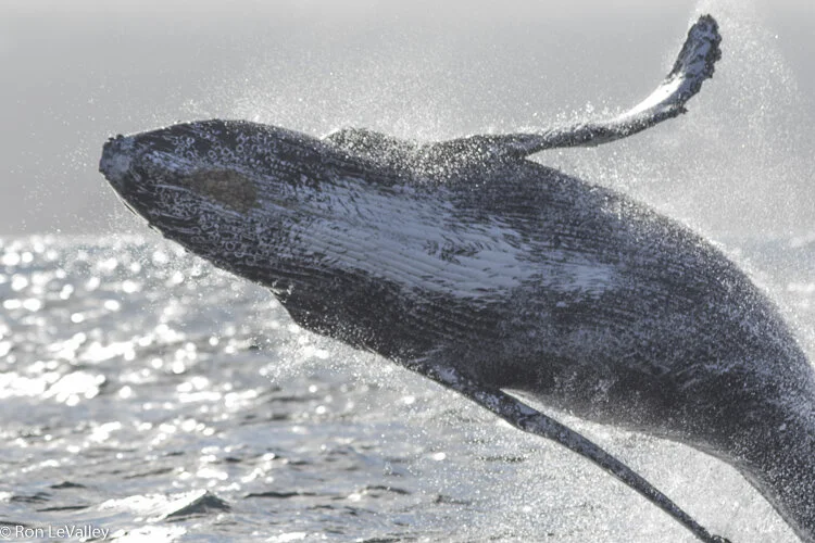
Humpback whale. Photo by Ron LeValley.
Whale entanglements in California linked to the marine heatwave
The pronounced marine heatwave of 2014-2016 led to changes in the local abundance of marine species found in the coastal ocean of the NE Pacific. One notable species composition change was that krill abundance decreased in 2015 along the central California coast. Humpback whales that preferably feed on krill along the edge of the continental shelf had to change to eating juvenile anchovy instead, which are generally found closer to shore. Following the food, whales also moved more inshore. As such, whales (humpback whales in particular) suffered increased entanglement in Dungeness crab fishing gear since they were frequenting shallower depths where crab fishing gear is set.
This unfortunate situation was even more highly pronounced in early 2016. The marine heatwave also led to a harmful algal bloom of a diatom the produces domoic acid, which accumulates in shellfish and makes them toxic to marine mammals and humans. The Dungeness crab harvest season was delayed in winter 2015/2016 due to the domoic acid contamination in the crab, and the fishing season was not opened until March 2016. The delayed crab harvesting season thus coincided with the annual spring whale migration northward along the coast. This intensified the temporal overlap between whales and crab fishing gear and led to even greater occurrences of whale entanglement (Figures below).

a) Monthly amount of Dungeness crab catch historically (blue bars) and in 2016 (red bars) illustrates the delay in the 2016 crabbing season. The dashed line indicates the humpback whale migration and the probable humpback whale occurrence in central California as a function of that migration.

b) The number of whale entanglements by month and year, showing the increased occurrence during the marine heat wave of 2014-2016 and the delayed crabbing season in spring 2016.
This research was published by Santora et al. in the journal Nature Communications, and you can find a link to the paper here. This study also inspired a poem by Sam Illingworth.